Mt. Konocti Hike with Views over Clear Lake
Mt. Konocti just sits there quietly on the south side of Clear Lake, watching the towns below, looking a little too calm for something that used to spit lava.

Locals know it’s technically a dormant volcano, but you still hear people call it sleeping, not dead. Hikers love it for the views, the silence, and the sense that you’re walking on something ancient. There’s nothing flashy here — just a solid climb and a whole lot of sky at the top.
A Brief History (Volcanic and Otherwise)
Mt. Konocti is technically dormant, but it hasn’t erupted in around 11,000 years, which geologically speaking, isn’t all that long. It’s part of the Clear Lake Volcanic Field, and while the mountain doesn’t rumble anymore, the geothermal activity nearby is a reminder that the earth under your feet still has a pulse.

Long before any hiking boots touched the trails, the mountain held deep spiritual meaning for the Pomo people. They believed it was home to powerful spirits, and even today, many local tribes see it as sacred land. Stories have been passed down about hidden caves, lost travelers, and mysterious smoke.
One of the more persistent rumors is that there’s a giant cave sealed off near the summit, supposedly with tunnels reaching all the way under the lake. It’s never been confirmed, but that hasn’t stopped the stories from growing with each retelling.
The Mt. Konocti Hike

If you’re doing Mt. Konocti, chances are you’re taking the Wright Peak Trail. It’s the most popular and the most straightforward path to the summit. The trail is about 6 miles round trip and gains around 1,600 feet in elevation, so it’s not a casual stroll, but it’s manageable if you’ve done a few hikes before. I’d call it moderately challenging. The climb is steady, with a few stretches that’ll have you feeling it in your legs, but nothing technical or sketchy.

The trail itself is mostly a wide, gravel fire road, which sounds boring on paper, but the scenery keeps shifting. You start out in oak woodland, then catch glimpses of the lake through the trees, and eventually make your way up to some wide-open views. On clear days, the sun hits the lake just right and makes the climb feel worth it before you even reach the top.

There are a few benches tucked into the trail where you can rest and take it in. Trust me, you’ll want to pause — not just for your legs, but to catch the silence. There’s something about this mountain that just turns the volume down on everything else.
What You’ll See at the Top
Once you hit the summit, it gets quiet in a different way. Not just from the wind or distance from the road, but in that you’re suddenly above everything. Above the lake, above the noise, above the towns. It’s just you and a whole lot of sky.
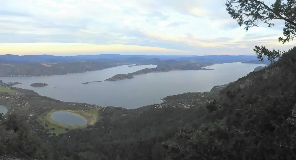
On a clear day, the view is unreal. You can see across Clear Lake in every direction, and if the air’s crisp, you’ll spot Mt. St. Helena to the south and the Sierra Nevada ridgelines way off to the east. There’s this slow, turning moment where you realize you’re looking at miles and miles of Northern California and barely any of it is touched by highways or big box stores. That alone makes the climb feel worth it.
There’s a fire lookout tower up there, though you can’t go inside. It’s fenced off, but still adds a bit of character to the summit. There’s also a picnic table or two and a few wooden benches that feel like they were built for people who aren’t in a hurry. You sit, eat whatever snack made it through the hike, and just let your brain unwind.
And for all the volcano talk, it doesn’t feel threatening up there. If anything, it feels like the mountain’s sleeping for a reason. Like it’s just resting, not waiting.
Wildlife and Plant Life
Mt. Konocti isn’t a jungle, but it has its own kind of life. Quiet, rugged, and a little wild. The lower part of the trail is full of oak woodland and chaparral. You’ll walk past twisted manzanita, gray pines, and brittle shrubs that smell like sun-baked earth and something ancient.
Birdwatchers love it here. Red-tailed hawks are almost guaranteed, and turkey vultures glide low enough that you’ll catch the patterns on their wings. Every now and then, if you’re lucky, you might spot a golden eagle cruising high above the ridgeline. There’s also the usual crowd: woodpeckers, jays, and the occasional flash of something smaller in the brush.
Deer show up if you’re quiet. They tend to stick to the shaded spots, usually early in the day. I’ve never seen a bobcat or mountain lion, but people have mentioned sightings. The only thing I actively watch out for in the warmer months is rattlesnakes.

They like to sunbathe on the path, especially where the trail opens up. Just stay alert and give them space if you do see one.
What I like most is how undisturbed it feels. No visitor center, no paved loop, no curated experience. The mountain is just doing its thing, and you get to walk through it.
Tips for Your Trip
Stick to the main trail
Wright Peak Trail is the only officially open and maintained route. While the mountain has a few other paths, most of them cross private land and aren’t open to the public. It’s tempting to explore side routes, but unless you enjoy guessing which “No Trespassing” signs mean it, your best bet is to stay on the marked path. The good news is you’re not missing out. The main trail already gives you everything: steady elevation, changing scenery, and one of the best lake views in Northern California.
Choose your season wisely
Summer hikes can be rough. The trail gets hot, especially the upper half, where the sun reflects off the gravel and there’s almost no shade. If you go mid-summer, start early and bring more water than you think you’ll need. Spring and fall are ideal — mild temps, clearer air, and fewer bugs. Winter is quieter, and you might get fog or even a dusting of snow, but check the forecast before heading up. The view at the top is the whole point, and it disappears fast when clouds roll in.
What to bring
At a minimum: water, sturdy shoes, and some layers. The temperature can shift fast as you gain elevation. A hat helps in the sun, and you’ll want a camera or phone for the summit. Cell service is spotty but not totally gone. Snacks don’t hurt either — there’s a picnic table near the top with a view that turns even a granola bar into a moment.
Getting there and parking
You’ll park at the trailhead off Konocti Road. The lot is small but rarely full unless there’s a holiday weekend crowd. No pass needed. Just be respectful of local driveways and don’t block the road. Some of the nearby property owners aren’t shy about putting up signs to remind you.